The SSA considers not just the factors that influence viability (Chapter 4), but assesses to what degree they influence risk (Smith et al. 2018, p. 6). Our analysis of the past, current, and future influences on what the eastern indigo snake needs for long-term viability revealed that there are several influences that pose risks to future viability of the species. These risks are related to habitat changes from urbanization and climate change. Urbanization affects habitat from residential & commercial development, road construction and expansion, energy development such as solar arrays and introduction of invasive species. Increased urbanization can also increase occurrence of direct mortality. While there will likely be indirect effects on eastern indigo snakes due to shifting changes in temperature and precipitation, rising sea levels are expected to directly impact coastal populations of eastern indigo snakes. Other important influencing factors are related to non-urban land use and land management such as fire management, forestry, mining, and agriculture. Therefore to assess potential future condition for the eastern indigo snake, we use projections of urban development and sea level rise to assess potential habitat loss and fragmentation and consider a targeted conservation scenario in which land use and management are included.
In constructing our scenarios, we considered two main influences by which species viability projections could be affected: conservation actions (positive influence) and habitat loss, fragmentation and direct mortality due to urban development and sea level rise (negative influence). Habitat quantity can be negatively impacted by sea rise inundation and development or land use change (particularly on private lands), or positively impacted by land acquisition, restoration, and/or repatriation into unoccupied sites that have suitable habitat.
Our scenarios reflect a range of levels of future urbanization based on the Slope, Land cover, Exclusion, Urbanization, Transportation, and Hillshade (SLEUTH) model (described further in the next section), and sea level rise based on National Oceanic Atmospheric Administration (NOAA) local projections, at 2 different time steps (years 2050 and 2070). Because there is uncertainty as to the level and extent of future urbanization, we use 3 scenarios to capture low, moderate, and high possible rates of urbanization. We also explore a conservation scenario in which impacts from sea level rise and the moderate urbanization rates are used as a baseline and in combination with conservation actions such as, repatriation of populations into areas of extirpation, surveying and monitoring (which may indicate higher current resiliency conditions than estimated), and increased conservation action (e.g. improved land management, restoration, and land protections) in focal areas to accelerate recovery. These four scenarios provide a range of viability predictions for the species from worst case to optimistic.
Urban Development
We use the SLEUTH models to determine areas predicted to be urbanized in the future. SLEUTH is a cellular automata model that applies transition rules to the states of a gridded series of cells, and in this case the transition is that from undeveloped to developed land cover, otherwise known as urbanization (Chaudhuri and Clarke 2013, pp.1-3) and has been successfully applied worldwide over the last 15 years to simulate land use change.
The SLEUTH model predictions for each 60m square cell are given as a probability of urbanization, ranging from 0-100%, and are modeled for each decade from 2010 (baseline) to 2100. For each of our time points (years 2050 and 2070), in the low development scenario we considered as developed only those cells with a probability of 90% or higher of being developed. In the moderate development scenario, we considered as developed all cells with a probability of 50% or higher of being developed (more likely to be developed than not). In the high development scenario, we considered as developed all cells with a probability of 20% or higher of being developed. To forecast viability using urban development projections, we assessed resiliency in the context of loss and fragmentation of eastern indigo snake habitat. See appendix D for additional information on the urbanization models used in this report.
Sea Level Rise
To estimate loss of habitat due to inundation from sea level rise for coastal populations of eastern indigo snakes, we used NOAA’s shapefiles available at their online sea level rise viewer (NOAA 2017). Projected sea level rise scenarios from NOAA provide a range of inundation levels from low to extreme. We chose the most likely scenario based on the Sea-Level Rise Working Group (SLRWG 2015), which corresponds to NOAA’s intermediate-high scenario. Local scenarios are available at 29 locations along the coast of Florida, with each scenario providing estimates of sea level rise at decadal time steps out to the year 2100. We determined the average sea rise level estimate for the intermediate high NOAA scenario across all 29 stations and used this estimate to project habitat loss at 2050 (2 feet sea level rise) and 2070 (3 feet sea level rise). Sea level rise impacted future resilience of eastern indigo snakes by influencing the population extent, habitat quantity, and fragmentation. See Appendix D for additional information on sea level rise projections used in this assessment.
Conservation Efforts
Eastern indigo snakes require large, relatively unfragmented habitat patches with a diversity of primary and secondary habitat types to maintain resilient populations. They are dependent on conservation to maintain and improve habitat mainly through adequate prescribed fire (for primary habitat) but also by managing invasive species. Long-term monitoring of eastern indigo snakes and range-wide population viability models will be critical to better understand population status. Long-term monitoring is on-going in a few locations (Orianne Indigo Snake Preserve, Archbold Biological Station, Pine Island Sound), however, methodology has varied greatly. Implementing more consistent monitoring in strategic locations could help better elucidate population conditions (including identifying additional populations) and inform land protection and management. Protecting additional habitat with corridors among populations will support resilient and genetically diverse populations. Finally, repatriation of populations into areas where the species has been extirpated may prove valuable for increasing species representation and redundancy.
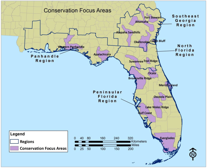
This targeted conservation scenario attempts to maintain, improve or restore eastern indigo snake populations in potential strategic areas (Conservation Focus Areas) across the historic range with the goal of conserving multiple highly resilient populations with sufficient ecological and genetic diversity. Redundancy will be achieved by maintaining multiple connected populations to allow genetic exchange. For larger populations this would maintain genetic diversity and for smaller population would reduce risk of extirpation of smaller populations (i.e. genetic rescue and recolonization after extirpation). Repatriation of populations in key areas of extirpation where there is suitable and conserved habitat could contribute to achieving higher levels of representation and redundancy. Other potential focused conservation efforts include additional land protection for populations with less than 25% of habitat protected (see Figure 24) and protection of dispersal corridors among and within populations to facilitate gene flow across the species’ range. Conservation action also would include adequate land management (e.g. prescribed fire) and long-term monitoring programs to better measure population trends over time.
The Conservation Focus Areas (Figure 26) were chosen because they contain potentially viable populations or because they will contribute to the connectivity of occupied eastern indigo snake habitat and thus increase dispersal between populations and improve opportunities for new population establishment. The primary factors used in delineating boundaries of Conservation Focus Areas were presence of: (1) intact, unfragmented (by major roads or river systems), naturally-functioning habitat representative of that area’s physiographic province that meet the medium or higher threshold for habitat fragmentation (25% of habitat is >20K acres patch size; or 50% is >10K acres patch size; or 75% >5K acres patch size ); (2) areas that in their totality, support genetic and ecological integrity of the species by including areas throughout the historical and current range of the eastern indigo snake and in both the Gulf Coastal Plain and Atlantic Coastal Plain; (3) areas that contain multiple, large acreages (greater than 2,500 ac (1,000 ha)) of conservation land such as public lands or property with conservation easements capable of adequate management (e.g., prescribed fire, wildlife corridors); and (4) diverse habitat types (e.g., scrub, sandhills, riverine sand ridges, etc.) as identified by our Eastern Indigo Snake Habitat Model (Appendix C). See Appendix E for additional detail on Conservation Focus Areas (CFAs).